May 26, 2023 - Flight Home from Florida Part Two
|
| I departed Waycross and headed due east to the coast, near Brunswick, Georgia. |
| |
 |
|
|
As I got closer to the coast, I saw huge parking lots filled with more cars than I have ever seen. Well, that big white building at center is a Mercedes-Benz USA vehicle preparation center.
|
| |
 |
|
| At the top part of the picture, on the East River, is a marine terminal where the big roll-on, roll-off ships tie up. Also up there are vehicle prep centers for BMW and Volvo. |
| |
 |
|
|
Not quite to the coast and Jeckll Island yet but I start turning north.
|
| |
 |
|
| Looking down at the attractive Sidney Lanier Bridge that crosses the East River. Brunswick is on the north side of the river at top left. |
| |
 |
|
| A good look at Jeckll Island. There is an airport at far right just prior to the treeline. |
| |
 |
|
| An oval-shaped island sits in the middle of the East River. Saint Simmons Sound at upper right opens to the Atlantic Ocean. |
| |
 |
|
|
Passing McKinnon St. Simons Airport Island. I landed there once in the Citabria. An upscale place with lots of jets, but they treated me right, as I recall.
|
| |
 |
|
| Some nice houses overlooking the marsh and then the ocean. |
| |
 |
|
|
Looking east out over the ocean. The skies were overcast and I was fighting a headwind.
|
| |
 |
|
| At first I flew over the inland marshes. |
| |
 |
|
| Finally I angled over to where the ocean meets the land. |
| |
 |
|
| Sapelo Lighthouse is just off my left wingtip. |
| |
 |
|
|
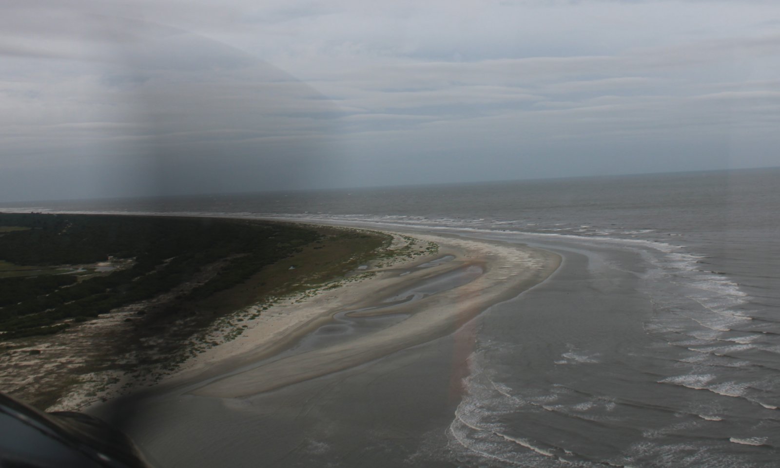
Not much of a beach. The trees come right up to the ocean on Sapelo Island.
|
| |
 |
|
| Continuing north. It was bumpy down low. |
| |
 |
|
|
|
| |
 |
|
| |
| |
 |
|
| Looking east at Tybee Island. This is where the good people of Savannah go to the beach. |
| |
 |
|
| And looking west up the Savannah River (south channel). Savannah itself is unseen in the distance. |
| |
 |
|
Looking down at Fort Pulaski in the middle of the Savannah River. |
| |
 |
|
| A medium-sized tanker heads up the river to Savannah, I guess. |
| |
 |
|
|
Funky-looking Tomkins Island off Turtle Island and Bloody Point. I'm now in South Carolina.
|
| |
 |
|
| It appears to me they built these houses a little too close to the ocean. Look carefully, half of them are on pillars that are in water. |
| |
 |
|
|
Some nice houses amist a golf course.
|
| |
 |
|
|
Looking east at Hilton Head Island on a not very good weather day. There is a towered airport over there.
|
| |
 |
|
| I looked down and saw this place which obviously was a military airfield at one point. It turns out it is Page Field on Parris Island. It was built in 1934 and probably supported the nearby Marine Corps training base for new recruits during World War II. |
| |
 |
|
| I saw this town just west of Page Field and thought it looked very military. Well, it should be because it is the famous Marine Corps Recruit Depot Parris Island! |
| |
 |
|
|
I continued northeast and flew on the east side of Beaufort Marine Corps Air Station. Then I decided I had had enough of getting bounched around, so I turned north, climbed and heading inland.
|
| |
 |
|
| I travelled through some light rain for awhile. |
| |
 |
|
| Passing over Low Country Regional Airport. It's not far to the east of I-95. Looks like it would be a good cross-country stop. |
| |
 |
|
| After awhile I flew out of the light green on my iPad/Foreflight, and about the same time intersected I-95. I turned northeast again and followed I-95. I was heading towards my next fuel stop at Lumberton, North Carolina. |
| |
 |
|
| Passing overhead a huge industrial site with some of those weird wood log donut things. |
| |
 |
|
|
Passing by Dillon County Airport, right off I-95. This is another airport I stopped at on the 2003 Miami to Baltimore flight in the Corben Baby Ace. I seem to remember there was a building by that airplane parking ramp at runway center but there is nothing there now. I'm wondering what is going on with this airport. The runway looks like it is in nice shape, but there are no hangars, no fuel services, no planes, no nothing.
|
| |
 |
|
|
A little further up I-95 and yes, there it is: the famous South of the Border! Anyone who has driven I-95 is well aware of it, as you start seeing South of the Border billboards hundreds of miles away in either direction. Although I've driven past it many times, I've never stopped to see Pedro. Maybe I will next time.
The attraction contains a miniature golf course, truck stop, 300-room motel, multiple souvenir shops, a campground, multiple restaurants, amusement rides, and a 200-foot observation tower with a sombrero shaped observation deck. It is also home to "Reptile Lagoon", the largest indoor reptile exhibit in the U.S. It also has a motocross training center.
|
| |
 |
|
|
There used to be across from South of the Border a large, colorful playground that was visible from the Interstate. We used to stop there and let the kids play there. But it is long gone. Down below is where it used to be.
|
| |
 |
|
| Lumberton Regional Airport was just a little further up I-95 from South of the Border. Here I am on base for runway five at Lumberton. |
| |
 |
|
| It's been a few years since I've landed here. This striking terminal building is clearly new. They are renovating the fuel farm area but I was able to get full service from a fuel truck at the same very low price as the self service: $5.15. |
| |
 |
|
| The main lobby of the new terminal building. |
| |
 |
|
|
The pilot's lounge, which you can get to after hours if need be. They also have a courtesy car. There are a ton of hotels and restaurants nearby. I really like Lumberton; it's a great cross-country stop.
|
| |
 |
|
| The runway is huge. Here I am about to take off. |
| |
 |
|
|
An aerial shot of the Lumberton terminal building.
|
| |
 |
|
| A little further up, I took this shot which contains a Comfort Suites motel we have stayed at a couple of times on our way down to Florida. Next to it is an Outback Steakhouse. |
| |
 |
|
| Yet another airport I stopped for fuel at on my Corben Baby Ace cross-country: Wilson Industrial Air Center (W03). The RV-7 clearly blows the old Baby Ace away in terms of range and speed. |
| |
 |
|
| Still following I-95 down below through North Carolina. |
| |
 |
|
|
Approaching the James River with Richmond off to the left. That bridge in the center is the Benjamin Harrison Memorial Bridge. The blue arrow points to City Point, which was Grant's headquarters from June 1864-April 1865, and where he directed the 10-month Siege of Petersburg from the grounds of Appomattox Plantation at City Point. Abraham Lincoln spent three weeks there meeting with Grant in April 1865.
A small port town at the confluence of the James and Appomattox Rivers, City Point had been connected to Petersburg by railroad prior to the war. Its strategic position next to the railroad bed and the rivers offered Grant easy access to points along the front, as well as good transportation and communications with Fort Monroe, Virginia, and Washington, D.C. When he arrived at City Point on June 15, 1864, Grant established his headquarters in a tent on the east lawn of Dr. Richard Eppes' plantation, known as Appomattox.
More important than being the headquarters for the United States Armies, City Point was the supply base for the Union forces fighting at Petersburg. Overnight the tiny village became one of the busiest ports in the world as hundreds of ships arrived off its shores bringing food, clothing, ammunition, and other supplies for the Union army. For example, on an average day during the siege the Union army had stored in and around City Point 9,000,000 meals of food and 12,000 tons of hay and oats. The only food not imported from the North was bread, which the army produced on site. In a bakery built on the grounds commissary personnel produced 100,000 rations of bread a day for the hungry soldiers fighting in the trenches.
There is a museum now in the building used as Grant's Headquarters at City Point; I'd like to check it out someday.
|
| |
 |
|
|
This painting by George P.A. Healey is titled "The Peacemakers". It is March 28, 1865 and General Sherman, General Grant and Admiral Porter are conferencing with President Lincoln on the USS River Queen at City Point, near Richmond. Less than a week before the fall of Petersburg, Virginia, the four men met to discuss the nature of the peace terms to follow. Lincoln would be assassinated on on April 14.
This was the war's only three-way meeting of President Lincoln, General Grant, and General Sherman. Also present was Rear Admiral David Dixon Porter, who wrote about the meeting in his journal, and later recounted:
"I shall never forget that council which met on board the River Queen. On the determinations adopted there depended peace, or a continuation of the war with its attendant horrors. That council has been illustrated in a fine painting by Mr. Healy, the artist, who, in casting about for the subject of an historical picture, hit upon this interview, which really was an occasion upon which depended whether or not the war would be continued a year longer. A single false step might have prolonged it indefinitely."
Sherman said, "I think the likeness of Mr. Lincoln by far the best of the many I have seen elsewhere, and those of General Grant, Admiral Porter, and myself equally good and faithful. ... the rainbow is Healy's—typical, of course, of the coming peace. ... It matters little what Healy meant by his historic group, but it is certain that we four sat pretty much as represented, and were engaged in an important conversation during the forenoon of March 28, 1865, and that we parted never to meet again.."
The painting hung in the White House Treaty Room from Kennedy through George W. Bush but now hangs in the Oval Office dining room.
|
| |
 |
|
| Looking southeast down the James River. Jamestown is out there in the distance. |
| |
 |
|
|
Looking at "The Peninsula" with the York River on the elft and the James River on the right. A lot of history took place on this Peninsula: Jamestown, Williamsburg -- Virginia's first capital --, the British surrender at Yorktown in the Revolutionary War, and the Civil War battles.
|
| |
 |
|
| Next up is the Rappahannock River on the left. Highway 17 is down below. Lynnette and I drove it a couple of years ago on our way to Yorktown, a very scenic drive I must say. |
| |
 |
|
| Looking northwest up the Rappahannock River and Highway 17. |
| |
 |
|
|
I flew over the Potomac River without taking a picture for some reason.
Now I'm approaching the Patuxent River with Patuxent Naval Air Station at center.
|
| |
 |
|
|
A closer look at Patuxent Naval Air Station, home of the Navy's Test Pilot school and R&D center.
|
| |
 |
|
| Passing by Chesapeake Ranch Airport (MD50), a little airport community. |
| |
 |
|
|
A big picture shot of the Blackwater Marsh, one of my favorite places to fly.
|
| |
 |
|
| Almost home. Passing by Bay Bridge Airport and the Chesapeake Bay Bridge. By this time the skies were clear and sunny and I was making 160 mph over the ground which is more like it. |
| |
 |
|
|
Two selfies in one day! I'm losing it.
|
| |
 |
|
| Safe on deck parked in front of my hangar. Chalk up another great trip in the RV. |
| |
 |
|
| |
| |
|
|
|
|
|
|